The "globe chart" below is from NASA’s website.
NASA and NOAA (Commerce Department) claim to know the planet's surface global average temperature since 1880. That is a lie. There were far too few thermometer readings in the 1800s (actually far too few before WW II) to estimate the Earth’s temperature in 1880 (or 1900, or 1920, or 1940).
Ph.D climatologist, and former NASA researcher Dr. Mototaka Nakamura, has written that over the last 100 years “only 5 percent of the Earth’s area is able show the mean surface temperature with any certain degree of confidence.”
Land surface thermometers are artificially warmed by economic growth near them over time, as buildings, roads and parking lots in the vicinity of weather stations. Many weather stations are opened, closed, or moved, often more than once, over a century. Airport locations have become more popular. Heat from jet planes and the tarmac cause artificial warming versus the prior locations, unrelated to carbon dioxide.
 Measurement equipment has been changed, usually more than once. Measurement methodologies have changed frequently for ocean temperatures = 70 percent of our planet. How do the government bureaucrat scientists adjust for all the measurement location and methodology changes over time? Whatever they do, is a guess -- their business, and not yours!
Every month a majority of square (red circles in the chart below) surface grids will have one or more days that are missing temperature measurements. The chart below shows many areas where the land surface has no measurements at all. A global average temperature requires temperature data for ALL surface grids.
So NASA and NOAA "wild guess" (aka infill) the missing data. I say wild guess for a good reason: There is no way to verify if the infilled numbers are even close to reality. No verification. Wild guessing by bureaucrats, where some of the high paying jobs depend on a continued "threat" from global warming. Wild guessing by bureaucrats, who have predicted continuous and dangerous global warming, and want their predictions to look good.
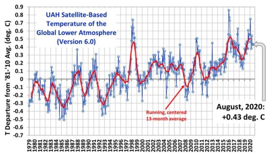
What could go wrong with this junk science? And why do NASA and NOAA completely ignore satellite-collected temperature data available since 1979? Satellite data require only a small amount of infilling over the poles.
And they are not affected by economic growth near the sensors. Most important, I believe: Satellites measure the greenhouse warming effect in the troposphere, where greenhouse warming happens. Warming on Earth's surface can have many causes other than a warming troposphere from greenhouse gasses.
Satellites are located in a very consistent environment. Satellite data since 1979 do show global warming, but less global warming than highly "infilled" surface measurements made in their ever changing environment. Less warming means you will never hear about UAH satellite data in the mainstream media! Nor will you hear about the poor quality and quantity of land surface temperature data in 1880 ... and still poor quality today in 2020 !
Surface grids with no thermometers, or missing data, require wild guesses for the missing data. In parts of Africa, for one sad example, NASA has declared RECORD heat in spite of the fact there are no thermometers in those surface grids to measure the temperature ! We just have to trust bureaucrats wild guesses, I suppose. But I don't trust this junk science of surface temperature measurements at all.
Our planet has been warming for about 20,000 years. More recently, there has been a mild warming trend since the cold, late 1600s. The exact amount of global warming since the late 1600s is not known. Probably at least +1 degree C., and probably less than +3 degrees C. So +2 degrees C. warming is a good rough estimate, +/- 1 degree C. There are data from central England shown in the chart below, but that's not global data. Most important: People living in the late 1600s complained that their climate was too cold ... because it WAS cold ! Those people would have been THRILLED if they had the warmer and more moderate climate we SHOULD be enjoying today.
Today, instead of people being happy with our wonderful climate, we hear climate science deficient leftists declaring climate change is an existential threat. Warmer winter nights in Alaska is an existential threat? And the alleged climate catastrophe they have "predicted " for the past 50 years, can only be prevented by electing leftists? And giving them great powers to micromanage our lives ! Wait a minute -- leftists wanted to be elected and micromanage our lives BEFORE they invented the coming cliomate crisis hoax. Their coming climate crisis nonsense is why this blog exists !
The moving chart below shows land surface thermometer coverage in 1880, and in 2020 -- the start and end years of the current NASA and NOAA global warming "measurements". Note that 1880 land surface coverage is so sparse that wild guesses of the missing data are far more important than the actual temperature data. Ocean temperature measurements were even more haphazard until a few decades ago. Note that in 2020 there are still large land areas with no thermometer coverage. Ocean temperature measurement locations are not shown, because no one ever recorded where the ocean temperatures were measured, by sailors with buckets on passing ships !
